Sit beside the river and sip a glass of wine after a long day at work. Lay yourself down by the river and relax after a long run. Go fishing, go rafting, go wading, go birdwatching.
As winter slowly starts to wind down, our river dreams start to flow. The Willamette River winds through Eugene and Springfield, and the McKenzie flows on the outskirts of town, but how often do we really see it from our urban streets?
Historically, city dwellers in Eugene and Springfield didn’t really view the riverfront as something to preserve for its clean water or ecological values, nor did they see it as a place to put cafés or open spaces to enjoy the scenery. The urban riverfront, prone to flooding, became home to gravel pits, dumps and industrial sites in Lane County’s early days.
But when the Willamette’s dams were completed in the 1960s, flooding was reduced (sadly, so was the salmon population) and the nature of riverfront development was primed for change. Fifty years later, it hasn’t changed that much. Gravel pits still pockmark the Willamette in north Eugene, and Glenwood’s riverfront is industrial and hemmed in with rip-rapped rock.
Now, as the city of Springfield envisions a new Glenwood riverfront, and as the UO Foundation looks to develop the Eugene Water and Electric Board site and as more opportunities arrive to bring the riverfront to the public eye, the question arises: Will the communities of Eugene and Springfield take up the challenge to not merely build along the river but protect it and connect it to the surrounding community? Is the answer a river commission, committee or study group?
‘A river is more than an amenity — it is a treasure that offers a necessity of life that must be rationed among those who have the power over it.’
— Oliver Wendell Holmes, U.S. Supreme Court Justice
Whether you are drinking from them (as water, beer or whiskey), building alongside them or working to preserve them, Lane County’s peaceful rivers are a controversial subject, leading easily to fighting and disagreements. But in order to preserve the river and its beauty, people, agencies and municipalities need to get along to some degree. Bringing up the idea of a committee to guide how the area’s riverfront develops arouses painful memories of past attempts to protect Eugene’s drinking water.
Eugene gets its water from the McKenzie, some of which flows through the Willamette National Forest and some of which flows through Lane County lands. In 2010, Lane County attempted to protect water quality, health and property by limiting future development in the floodway, floodplain and riparian area. A furor arose among homeowners, and 400 angry people showed up at a meeting to discuss the plan. Not long after the crowd attempted to force a recital of the Pledge of Allegiance, the proposal was tabled by the Lane County Commission.
Mentioning a commission or a committee to guide riverfront development stirs up those bad memories for people like Joe Moll of the McKenzie River Trust. His nonprofit has worked to restore gravel pits near its Green Island property at the McKenzie River’s confluence with the Willamette north of Eugene as well as collaborated with EWEB to create the Berggren Demonstration Farm, which showcases the connections between clean water and farming.
A commission could add value to policy makers by providing distilled, thoughtful information, Moll says, despite his caution. “I’d love to see the ends that a well-functioning board could produce.”
Committees in the past have been successful at protecting the waterways. In the 1960s and ’70s as the dams sprang up, so did the idea of the Willamette Greenway, a state and local effort, which became known as Goal 15, with the stated intent to “protect, conserve, enhance and maintain the natural, scenic, historical, agricultural, economic and recreational qualities of lands along the Willamette River.”
The Greenway started off as a project of governors Bob Straub and Tom McCall, but it came into being via Greenway committees that worked to bring the idea to fruition. In 1976, Straub established a 21-member committee to advise the governor on management and design of the Greenway, according to an archived issue of The Register-Guard, which also called the Greenway a “pet Straub project.”
The Willamette Greenway and its riverfront protections have been eroded over the years, critics say. Alvin Urquhart, a UO professor emeritus in geography, in the late 1980s took Eugene and the university to task in a lawsuit over the Greenway, “which I think was being perverted by trying to build the [Riverfront] Research Park,” he says. That plan, he says, called for buildings along the river with a 20-foot setback. It saw the Greenway as vacant land to be developed, he says, not preserved.
In 2012, when the UO’s Riverfront Research Park finally broke ground on its first construction project in 14 years, it was located on a site between two existing buildings, not on the riverfront as the plans had first called for. Yet even that recent change to preserve prime riverfront land came after years of fighting.
Today, Urquhart says he is still concerned about the riverfront because “there is no uniform direction, everything is going in piecemeal.”
The riverfront “needs to be paid attention to as the possibilities get whittled away one thing at a time,” he says. “The goal is really in my mind to maintain as much open space as possible along the river, maintained as something that’s available to everyone rather than primarily people who want to build and take advantage of its attractive character for their own use.”
‘There’s a river somewhere that flows through the lives of everyone.’
— Roberta Flack, ‘River’
Some, like Willamette Riverkeeper Executive Director Travis Williams, have brought up the idea of a Greenway 2.0. Until recently Willamette Riverkeeper has had a larger presence in Portland than Lane County, but new efforts by Michelle Emmons, its Lane County outreach coordinator, have involved cleaning up trash along the river.
In some cases, part of the battle has been figuring out who is responsible for the land that sits piled high with waste — the UO, the railroad, the city?
“What I have noticed even in the last three months working on trash,” Williams says, “is it seems like on that issue there’s been a lack of communication, a lack of partnership, and it seems like that’s changing.”
Seeking to balance the needs of the environment with the plight of the urban homeless, whose camps are blamed for the worst of the trash, he asks, “How do we together deal with this situation and address it as we move forward with the appropriate sensitivity?”
For Nena Lovinger of LandWatch Lane County the focus needs to stay on protecting the environment: “Communitywide we need to pay close and caring attention to the river and riverfront through town and beyond,” she says. “Having a ‘river commission’ would be good — a commission committed to riverine health and not deleterious development and chemical abuse along the river banks.”
Dilution has been the solution when it comes to waste and rivers. In addition to Lane County’s treated sewage-waste releasing into the river, businesses discharge pollutants and the area’s stormwater flows into the Willamette, either directly or via its various tributaries such as Amazon Creek. In a sense, it is legal to pollute the river, as long as the pollution falls within permitted levels.
Springfield has been addressing the stormwater issue as well as restoring waterways, such as through the $9.7 restoration of its millrace off the Middle Fork Willamette that was completed in summer 2014. A planned $3.5 million stormwater treatment facility near downtown will not only clean polluted runoff before it reaches the millrace but provide recreation and a path along the waterway, as well. “People want more access to the river,” says Molly Markarian, senior planner for the city of Springfield’s Development and Public Works.
When asked if and how cities like Eugene and Springfield could coordinate their riverfronts as the Willamette runs along Eugene, Glenwood and Springfield, Markarian points to the Rivers to Ridges Partnership. That partnership, focusing on parks and open space, brings together the cities, the county, conservation organizations, federal agencies and more to both protect and enhance the waterways. It seeks to provide recreation and environmental education and encompasses about 4,700 acres of land across the county and the rivers’ confluence.
UO professor emeritus of landscape architecture Jerry Diethelm says yet more is needed. “Eugene needs to get outside of itself and hire a national figure to do some conceptual park and open space planning, to give us something to shoot for that is bigger than next year’s budget limitations.”
Diethelm continues, “I’m convinced that Eugene needs that kind of greater horsepower to take a needed next step with its overall thinking about the riverfront, downtown and metropolitan area.”
And what about the metropolitan area, that urban river — those areas of the Willamette where buildings, roads and industry abut the riverfront? The river, flowing through cities full of restaurants, has only three places where people can sit and chat over coffee or a beer and watch the river flow by.
It’s a fine line. In order to love the river, people need to experience the river. But when we crowd natural areas, we harm them.
‘Never in his life had he seen a river before — this sleek, sinuous, full-bodied animal, chasing and chuckling, gripping things with a gurgle and leaving them with a laugh, to fling itself on fresh playmates that shook themselves free, and were caught and held again.’
— Kenneth Grahame, The Wind in the Willows
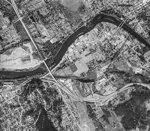
For that urban example, Markarian points to the Glenwood Refinement Plan as an example of an area with redevelopment potential that she says has had extensive public input. Glenwood is about one square mile of land surrounded by the Willamette, I-5, Eugene and Springfield.
As landowners along Franklin and the city of Springfield field inquiries from various developers who might be interested in Glenwood, Markarian says the city — which has held Glenwood under its jurisdiction since 1999 — has been looking at the public’s desire for a multi-use path as well as at restoring the riparian area, floodplain, stormwater and more. The goal for Glenwood, she says, is to have an active urban environment near the river with commercial, office and residential opportunities, while remaining mindful of the resource that is the river.
There are similar goals for the other big oncoming riverfront development — the 17-acre EWEB riverfront redevelopment by the UO Foundation. The land, which has been industrial for most of the past century is now, according to EWEB spokesman Joe Harwood, poised to be “the kind of development that people want to see along the last undeveloped portions of the riverfront.”
Jeanine Parisi, EWEB’s outreach coordinator, says an area that is now largely asphalt will do a much better job of treating stormwater before it reaches the river, and she says bioswales to treat runoff, green roofs and green streets are “codified in the zoning. This is a site that’s ripe for environmental repair.” The community has given years of input, she says. “Now it is up to the developers.”
These projects are still, as Urquhart calls it, piecemeal.
However, Robin Hostick, planning director with the city of Eugene, enthusiastically points to one example where governments and agencies worked together to come up with a plan for the river. It started off with what Hostick calls a “wonky” name — the Lane Livability Consortium’s Franklin Corridor Catalytic Project — but the final project is “The River Districts,” a vision of Eugene, Springfield and Glenwood connected by and celebrating the river.
‘Sometimes, if you stand on the bottom rail of a bridge and lean over to watch the river slipping slowly away beneath you, you will suddenly know everything there is to be known.’
— A.A. Milne, Winnie the Pooh
“What everybody likes about it is we’ve done all this great planning,” Hostick says of The River Districts. He points to Walnut Station near the UO, Glenwood and EWEB. “They all fit together.”
He says the consortium, with a grant from U.S. Department of Housing and Urban Development, chose the river as a place to find a common goal, and toward that end it brought together Eugene, Springfield, Lane County, the Lane Transit District (LTD) and the UO. He says the project was presented to Mayor Kitty Piercy and local luminaries in 2014, but the funding has since run out.
The Lane Livability Consortium used the Franklin corridor to bring together what the consortium calls the “river districts” made up of the Eugene Downtown Riverfront District and Federal Courthouse District, the UO, Riverfront Research Park and the Walnut Station District, and Springfield’s Glenwood Riverfront District.
Hostick says that “down Eugene to Springfield along Franklin — that feels like disconnected; it feels like a highway.” He asks, “What could we do to change that? Make it feel like a seamless, safe connection between the two cities? It could be totally transformed.” Hostick says, “Getting used to the idea of working together as region, that’s what this is all about.”
The River Districts project shows that the question is not whether governments and agencies can get along and formulate a vision for the river — they have. The question, according to longtime land-use advocate and former County Commission candidate Kevin Matthews, is about the river itself and making sure any consortium or river commission has an ecological perspective to coincide with the potential for development. “Done in a really collaborative and inclusive way, the regional economic development aspirations so clear in the plan really could happen.”
But “when you read the plan, it’s kind of striking that it’s all talking about the Willamette River, but there’s nothing about the river itself in the plan,” Matthews says. None of the conservationists or environmental advocates EW spoke to were aware of the River Districts project.
“In theory, all these government agencies that created this working group, in theory they are all public servants and going to incorporate an environmental perspective, but it sure didn’t happen,” Matthews says, noting with skepticism that the plan mentions a corridor to Goshen and LCC, areas that developers have eyed for urban expansion.
Reservations aside, having a commission that incorporates the goals of The River Districts with ecological concerns is “a super idea,” Matthews says. “The potential is to transcend business as usual.”
According to Matthews, “The idea of having all these partners working together would allow you do to something better, but they need to have the other stakeholders at the table or they are not going to transcend business usual.” The willamette river running through glenwood circa 1973. Photo taken for the WIllamette Greenway project.