It flows through the city; it flows past parks, gravel pits and buildings, but unless it’s rising up in a winter flood or we happen to glance down while driving over the I-5 bridge, the Willamette River rarely seems to flow through our minds. Eugene is a river city; the Coast Fork Willamette and the Middle Fork come together to the south and the McKenzie River, the source of Eugene’s drinking water, has its confluence with the Willamette to the north. The river goes through the heart of town, carrying our waste, our stormwater and sometimes ourselves — in fishing boats and on inner tubes. It winds its way northward past Corvallis and to Portland where it joins the Columbia and spills out to sea. The river, literally and figuratively, defines us, but the majority of us never think very much about it at all.
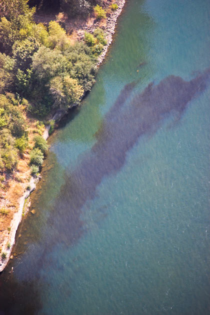 |
| A murky industrial “mixing zone” in the willamette near Halsey. Photo by Camilla Mortensen. Aerial support by Lighthawk. |
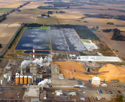 |
| Water is treated at a pulp mill before being discharged into the Willamette. Photo by Camilla Mortensen. Aerial support by Lighthawk |
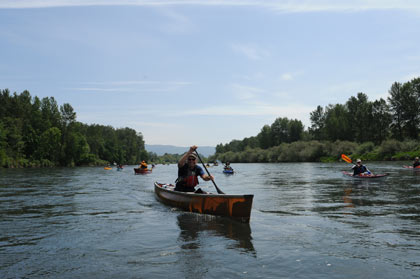 |
| Paddling with Willamette Riverkeeper 8 miles downstream from Eugene. Photo courtesy Travis Williams, Willamette Riverkeeper. |
The Willamette River is both meticulously planned, permitted and controlled and yet never completely controllable. As we look to a future of climate change, what President Obama recently called “the destructive power of a warming planet,” Eugene is planning around the river, but like most cities, not necessarily planning for global warming’s effect on the river such as wintertime flooding and summertime drought. Is the best way to love the urban river to try to make it natural again, or would the Willamette benefit if more urban dwellers had access to the river, even if that access was sitting in a restaurant rather than a park?
In the Eugene/Springfield area there are only three places someone can buy a drink and sit at a table by the river: McMenamins North Bank and Valley River Inn in Eugene and Roaring Rapids Pizza Company in Glenwood. “It’s a catch-22,” says Joe Moll, executive director of the McKenzie River Trust. “Do we want concrete to the edge of the Willamette? Not really.” But he and other river advocates say at the same time in order to get people to understand how much the river matters they need to be able to experience it, even if that experience for a city dweller is sitting at a table, under an umbrella, sipping a drink with a view of the water.
“People can get there and sit, listen to the water and watch the birds fly by,” Travis Williams of Willamette Riverkeeper says. “Part of that helps build that connection to the river — most people aren’t boaters and aren’t inner tubers.” Connecting to the river might be what saves what is left of the natural river in face of global warming and growing populations.
Water Flows
Fly over the river in a plane and what looks from the ground to be a fairly straight flow of water is actually a twisting snake of a river. Thanks to human engineering, the Willamette twists a lot less than it used to. “Our ability to manipulate the river far outstrips our ability to think ahead,” Moll says. An animal behaviorist before he became a river advocate, he points out that catastrophes tend to be what get our attention in terms of risk, and evolutionarily humans aren’t necessarily hardwired to think about long-term consequences. Those consequences include impacts from industry, homes, pavement, natural disasters and gradually warming temperatures.
The historic manipulation of the river is one reason Eugene has the urban riverfront that it does today, says developer Hugh Prichard. The last of the Willamette’s 13 dams was built in the 1960s, he says, and before that historical flooding meant that the riverfront through Eugene was not seen as developable. Much of the damming up the river and the zoning in towns down the river was done in the ’40s and ’50s, he says, adding that the feeling at the time was that areas along the river that could flood were not suitable for houses and restaurants but instead better as industrial sites. The dams, while bad for fish, were good for controlling the Willamette’s flooding.
Before damming the river, the Army Corps of Engineers also removed side channels and islands to improve the river for navigation in the mid-to-late 1800s to allow steam-powered paddle-wheel boats and other large craft to ply the waters, sometimes as far south as Eugene. Later, towns and gravel mines concreted and rip-rapped the riverbanks to control the channel and the river’s tendency to flood and to meander. Eugene, Springfield and other cities began to empty our industrial waste, sewage and stormwater into its flows, all of this leading to the urban river we now have.
Warmer Waters
In recent years restoration projects along the Willamette have tried to undo some of the effects of past wrongs to the river. Moll’s McKenzie River Trust works to restore islands, side channels and woody debris. Watershed councils work to restore tributaries such as the Long Tom River and in urban Eugene the Be Noble Foundation is trying to buy the land where the headwaters of Amazon Creek lie. But the river is facing a new challenge, one that though we recognize it, we aren’t required to plan for: climate change.
“We’re expecting more winter rain instead of snow, less snowpack, less late spring and summer flows,” says Babe O’Sullivan, the city of Eugene’s sustainability liaison. Lower summer flows could affect the river’s ability to dilute wastewater and more winter flooding could bring more contaminants into the water.
“The plans that are currently in place don’t account for climate change but it’s something we are working on,” O’Sullivan says.
Matt McRae, a climate and energy analyst with the City Manager’s Office, says that they are specifically looking at critical infrastructure — things like hospitals, police departments, fire departments, schools because they tend to be shelters — and making a plan to over time to move infrastructure away from the river, outside of the flood zone, because of a recognition that “that flooding is likely to intensify here, both river flooding and urban flooding in the streets.”
When Eugene does its planning around the Willamette, it takes into account natural disasters such as historic flooding and earthquakes, says Carolyn Burke from the city of Eugene’s Planning Division. It also takes into account statewide planning goals that were put into place to protect timber and farming and prevent urban sprawl. Goal 5 sets standards for open spaces, scenic and historic areas and natural resources. Goal 15 established the Willamette Greenway, which says that space, public access, native vegetation and scenic views must be considered when planning new developments. Though Nena Lovinger of LandWatch Lane County warns, “The Willamette River Greenway Program has good intentions but no teeth.” She says, “It lacks strong legal hooks needed to prevent development that damages natural, scenic and historical aspects of the riverine environment.”
That riverine environment is altering thanks to climate change, but according to Philip Mote of the Oregon Climate Change Research Institute (OCCRI), most state and municipal governments are not required to use best available science to plan for future issues, such as global warming. Eugene and Lane County are no different, but Eugene is trying to take a different tack, according to McRae, and bring climate change into the equation in its planning.
“We need to look at risk as changing over time,” he says.
McRae says that though the Federal Emergency Management Agency (FEMA) is coming out with new planning maps, those new maps don’t include climate change as a variable, and the maps are not going to project climate change onto projected precipitation patterns. As part of Envision Eugene, in which the city is planning growth for the next 20 years, the city is considering taking climate change into the equation, something that is key when dealing with a living river flowing through town.
Eugene and Springfield haven’t always made the best planning decisions for critical infrastructure even based on historical data. Sacred Heart’s RiverBend hospital was built in a floodplain and the Eugene Police Department’s recent move to Country Club Road puts those emergency responders in the floodplain as well, leaving those emergency services vulnerable in a flood.
McRae says the city is “chipping away” at improving the way it deals with stormwater, partnering with the Long Tom Watershed Council to retrofit existing private properties along Amazon Creek, whose waters eventually flow into the Willamette, with features such as bioswales, raingardens and permeable pavement.
According to OCCRI, climate change-induced increasing rain and decreasing snow in the Cascades will affect water supplies: “Recent research, using sophisticated observations, climate models and Northwest U.S. hydrological models, indicates that as much as 60 percent of these changes in the water cycle result from human activities. The chances for a water crisis are high in Oregon.”
Warmer and lower-flowing streams affect water quality for humans and fish, more frequent storms mean paved urban areas will be more prone to flooding and warmer temperatures and less water in the summer means more unmet demand for water.
And McRae says, “Everybody acknowledges that no one has a crystal ball” when it comes to population projections, and he says that climate change could throw a “wild card” into predicting the amount of people who could move to Eugene in the next 20 years, possibly fleeing drought and rising temperatures in areas like the Southwest, and competing for space and water.
While Eugene doesn’t currently pull its drinking water from the Willamette, we do send our treated and cleaned sewage into it. And downstream cities such as Corvallis pull their water from the river. Lance Robertson of Eugene Water and Electric Board says that EWEB has an interest in the Willamette as a backup source for water because Eugene, which gets its water from the McKenzie, is “one overturned chemical tanker truck on Hwy. 126 from being out of water.”
Water Woes
One thing that Eugene does have along the river is parkland, says Jeff Krueger of the Lane Council of Governments. He has been part of a Rivers to Ridges partnership that asked people to envision what they would like to see the river be in 30 years. There are 15 miles of paths along the Willamette corridor, he says, and one of the things people wanted for the river was connectivity. He says to picture the Willamette as a necklace with parks such as Mt. Pisgah, Dorris Ranch and Alton Baker as its pearls. Some, he says, need polishing while others need to be added.
Delta Ponds is an addition that is cited often. Former gravel pits, the ponds have been rehabilitated, Krueger says, into recreation and habitat where you can find juvenile Chinook salmon, western pond turtles and other native species. The extension of the paths in Delta Ponds in particular has really good benefits in terms of public use and getting people down to the river, Krueger says. They give direct river access to a huge population of north Eugene. Pointing to the ponds and to other bike and open space projects, he says, “No one should drive 40 miles for a bike ride or to get into a canoe.”
“In our area we have very little development that goes right up to the river that is residential or retail,” says Krueger, a landscape architect, adding, “Older commercial, industrial uses may not be the highest and best use for urban portions of the river.”
Those commercial and industrial uses have, and will continue to have, effects upon the river through town. While the gravel pits at Delta Ponds were shallow — only 12 to 15 feet deep — and made for good ecological restoration, other pits that are along the river are more than 100 feet deep, sometimes as much as 200 feet deep making them difficult, if not impossible to restore.
Moll points out that at least one portion of Alton Baker Park was historically a dump site, and he wonders what effects flooding could have on what remains there. The Oregon Department of Environmental Quality says the dump accepted liquid and chemical wastes from the JH Baxter wood treatment plant, possibly including creosote, coal tar, pentachlorophenol and chlorodibenzodioxins, but information on hazardous materials disposed at the landfill is not available for most of the 11 years of operation. In 1974 when the landfill closed, the entire site was covered with a minimum of two feet of sandy, silty loam and grass was planted over it.
Water Views
“People care more about something they have access to,” Krueger says. In order for people to comprehend how much we affect the river and how important the river is to us, they need to do more than just drive over it on their way south from Portland. “I don’t know how many times the word microbrew came up,” Krueger says of conversations on how to best use the river and potential riverfront sites.
Eugene has the 27-acre EWEB site to look to as it tries to balance open space, river values and development. The site has been used for storage and operations since the 1950s, but EWEB has been moving that over to a new location on Roosevelt. “It’s been pretty heavily used,” Robertson says. A portion of the site was home to a coal gasification plant that dates back to the ’20s and ’30s, before EWEB owned the property. “There is some soil contamination there that if that portion of the site were to be developed would have to be dealt with,” Robertson says. He says the previous owners would be responsible for the vast majority of the clean-up costs.
For industrial properties such as EWEB, or heavily used commercial properties such as the ones along the river in Glenwood that are undergoing a refinement plan process, “Habitat restoration might not be the most bang for the buck,” Krueger says.
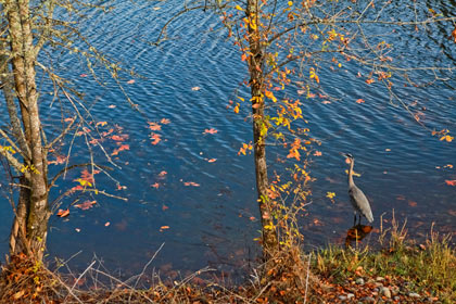
Goal 5 planning means that there is to be a 100-foot setback from the top of the bank to where development begins and most private development can’t take place there. Goal 15’s Willamette Greenway means that in some areas there is much more open space along the river. Williams of Willamette Riverkeeper says he thinks a good riverfront development would have a riparian zone throughout with 30 or 40 feet of willows, more mature stands of cottonwoods, “a basic buffer a great blue heron can duck into when people walk by” and then gaps where people can get down to the river and have a view.
Robertson says that EWEB went through an extensive master plan planning process and that the EWEB site master plan should go before the Eugene City Council and the city’s Planning Commission in early 2013. The “master plan fits what the community wants for this site,” he says, both protecting the riparian area where the land and river come together and allowing people to enjoy the riverfront to create something that is aesthetically pleasing. The plan calls for open space, mixed-use apartments and retail, Robertson says.
In addition for planning for the changing river, part of the challenge lies in putting in infrastructure like roads, cleaning up the coal gasification plant and deciding on what to do with historic buildings like the old EWEB steam plant, which Robertson says has pipes made with asbestos but has been suggested as spot for a brewpub or steam museum. Once the master plan is in place, the site just needs a bunch of people with money to come in, Robertson says, adding, “It’s a pretty prime piece of real estate for someone who believes in communities and rivers.”
Developer Hugh Prichard agrees, “It’s a great opportunity for people to think about what would be most attractive and would what be best for the most people, and those are not necessarily two different things.”
Moll of the McKenzie River Trust waxes a little more philosophical about the river in the face of a changing climate: “The more pertinent question becomes ‘If that is what I believe, then what can be done about it all?’” He says, “I think encouraging people to enjoy, use, see, touch the river gets at that in some ways — encouraging self-interest and satisfaction in the immediate time frame and then appealing to a sense of legacy — that this is what we want our grandchildren’s grandchildren to have access to in the future as well.”